")
")
WEST
Quantifying mineral dust emission as a function of land use: the example of southern Tunisia
The aim of the project was the development, and validation of a physically-based wind erosion model that would allow the quantification of dust emission as a function of land use so that the anthropogenic contribution to the atmospheric dust burden could be quantified.
Main results:
As a first step of the project, we installed 6 plots to follow wind erosion throughout the year in different places representative of the main land use types encountered in southern Tunisia: rangeland on sand, rangeland on pediplain, olive grove, Chott, cereal field, and oasis. These measurements (Fig. 1) showed that wind erosion was very intense in rangelands (up to more than 700 kg m-1 month-1 in January in the rangeland on sand). On the opposite, wind erosion was equal to zero in the oasis, which validates the hypothesis made in the model to consider oasis as non-erodible, and very low in the olive grove (less than 10 kg m-1 month-1 whatever the month). When the Chott was not flooded, wind erosion may be important (up to more than 100 kg m-1 month-1 in June). Finally, wind erosion in the cereal field was greatly reduced by the development of crops (from 265 kg m-1 month-1 in January to nearly zero in April) that occurred during the windiest period of the year (late winter-early spring); wind erosion was re-activated when the field was totally cleared after the harvest.
The second step of the project was to implement in the Dust Production Model (DPM) developed by Marticorena and Bergametti (1995) in the LISA (i) the parameterization of Fécan et al. (1999) to account for the impact of soil moisture on the wind erosion threshold, and (ii) the parameterizations developed by Kardous et al. (2005a; b) to account for the impact of tillage on wind erosion. In parallel, the computation of the wind erosion flux as a function of land use was also implemented. The simulation was made for years 2013 and 2014 using the meteorological forecasts at T0 from the ECMWF with a horizontal grid spacing of 0.1°×0.1° and the surface feature database produced by Labiadh (2011) for the four southernmost governorates of Tunisia.
The simulation made using this configuration of the DPM was shown to clearly underestimate the computed wind erosion flux. We found that the underestimation of wind erosion fluxes came from an overestimation of the soil moisture computed by the ECMWF Land Surface Model (LSM). This problem was also encountered by Xi and Sokolik (2015) using the WRF-Chem-DuMo model with the Noah land surface scheme: the use of the Fécan et al.’s (1999) parameterization in their regional simulation totally suppressed dust emission. This suggests that the semi-empirical parameterization of Fécan et al. (1999) could not be applied at the regional scale since the top layer of LSM (some cm) is still too deep compared to the soil layer concerned by wind erosion (a few mm). It was then decided to compute wind erosion flux without accounting for the impact of soil moisture.
Model results showed that wind erosion was active on the whole south of Tunisia except in the mountain highs (Fig. 2). In the simulation, wind erosion mainly occurred in rangelands (for year 2013: about 6.7×10⁶ kg m-1 vs. 1.4×10⁵ kg m-1 for cultivated areas), which is the dominant land use in the model domain. The simulated annual cycle of wind erosion, with 70% of the simulated fluxes occurring between March and June, and minima observed during the summer (July, August, September) and winter months (November, December, January), is in agreement with the literature (e.g. Prospero et al., 2002), and the measurements acquired during the project. In terms of intensity, modelled wind erosion fluxes are greatly underestimated in the rangeland on pediplain, because of an underestimation of wind speed intensity. On the opposite, modelled wind erosion fluxes are overestimated in the Chott, which can be explained by the fact that the model does not account for wind erosion inhibition due to the Chott flood. Wind erosion modelled in the olive grove is in the same order of magnitude as measured wind erosion.
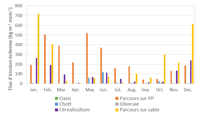
Figure 1: Wind erosion flux (monthly average for years 2013-2015) measured in the 6 plots installed in different places representative of the main land use types encountered in southern Tunisia: rangeland on sand (yellow), rangeland on pediplain (orange), olive grove (grey), Chott (blue), cereal field (violet), and oasis (green).
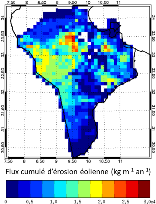
Figure 2: Cumulated wind erosion flux computed for year 2013 on southern Tunisia.
Contact LISA : C. Bouet (PI)
Support : Projet INSU LEFE action CHAT (janvier 2014 – décembre 2015)
Partners :
• iEES Paris – Institut d’écologie et des sciences de l’environnement de Paris, SU/CNRS/INRA/IRD/UPD/UPEC
• IRA – Institut des Régions Arides de Médenine, Benguerdane et Kébili (Tunisie)
• LISA – Laboratoire Interuniversitaire des Systèmes Atmosphériques, CNRS/UPD/UPEC