")
")
Quantification of the exportable "net" emissions: the case of the Sahel
In the Sahel, aeolian soil erosion predominantly occurs between May and June, at the beginning of the rainy season when the seasonal vegetation has not yet begun to grow. Aeolian erosion occurs in the form of short-term events associated with the passage of mesoscale convective systems (MCS), which are usually accompanied by precipitations. On the one hand, MCS produce intense dust emissions, and on the other hand a wet deposition leading to a removal potentially very efficient of emitted dust. The quantification of net emissions from this region therefore requires achieving a complete balance of the terms of emission and deposition. It is therefore necessary to ensure that the dry and wet deposition processes are correctly represented in the models. The device of measurement of particle size-resolved vertical flux deployed at the site of Banizoumbou during AMMA allowed documenting a clear case study of dust deposition. The analysis of the measurements allows the experimental determination of the rates of global and size-resolved deposition. On the other hand, the measurements of wet deposit on three Sahel measuring stations since 2006 allow assessing the washout ratios and their dependence on the precipitation rate
It is also necessary to assess whether the vertical redistribution induced by convective systems allows a contribution of Sahel emissions to long distance transport. This means to achieve high-resolution numerical simulations of convection and mineral aerosols (model RAMS, al. LaMP) which are then validated by measurements at the ground-based site of Banizoumbou and on the French SAFIRE ATR-42 research plane. After an initial assessment carried out on a well-documented event of the experimental point of view, the simulations are extended to seasonal and regional scales.
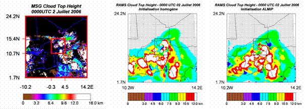 |
High resolution simulation of a convective system performed on July 2, 2006 in Niger. The images allow visualizing the fraction of clouds associated with the system observed by satellite (left) or simulated for two initial conditions of soil humidity (homogeneous or including a south-north gradient resulting from the AMMA Land surface Model Intercomparaison Project ALMIP) (Bouet et al., in prep.)